Mosaic - 360º Street View Imagery
REQUEST A MEETING
Mosaic: the preferred choice for pre and post disaster imagery collection. Mosaic cameras have proven themselves capable of reliably capturing highly perishable 360º street view imagery following natural disasters - including floods, fires, tornadoes and hurricanes - for days and weeks on end without fail. Imagery collected can be captured, processed and shared with relevant parties, all within 24 hours, in order to understand the real-time conditions and make time-sensitive decisions.
We are the only company in the world building robust, 360° cameras specifically for ground-level mapping and imaging at scale, with available services combining our hardware, logistics know-how, and delivery of data in one vertically integrated solution.
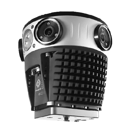
Mosaic 51 Mobile Mapping Camera System
The most durable, precise and practical 360º camera for urban mapping and surveying. All-in-one solution for mobile mapping and street view data collection.
- 12.3K resolution for the clearest image available
- All-in-one-solution, on-board GPU, no computer necessary
- Robust industrial grade construction, IP64, use it anywhere no matter the environment
- 360º camera for HD surveying, GIS, and infrastructure inspection.
- Easily manageable, standalone unit, single manned operation with minimal training
- Robust industrial frame & connectors to withstand the cold, the heat, water, dust, poor road conditions.
- Built-in computer, large internal storage to capture all day without a computer on board.
- https://www.mosaic51.com/cameras/mosaic-51/
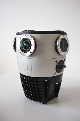
Mosaic X Mobile Mapping Camera System:
Where speed meets accuracy in 360º street view mobile mapping. Map large areas at highway speeds in extreme resolution for 3D models & reconstructions
- 13.5K resolution
- The highest quality street view imagery collected at scale with the most robust global shutter mobile mapping camera.
- Standalone system, easy-to-use interface to control during capture.
- Distortion-free capture for clear, precise shots at high speeds.
- Enhanced low-light performance boosts operational hours in challenging conditions – dawn, dusk, cloudy days, & tunnels.
- Seamless post-processing stitching, ideal for detailed visual documentation.
- Future-proof solution system with the ability to integrate additional devices (i.e. LiDAR, GNSS, IMU) per customer demand.
- https://www.mosaic51.com/cameras/mosaic-x/
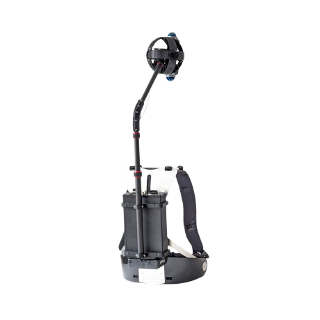
Mosaic Xplor - Mobile Mapping Backpack System
Trailblazing portable reality scanning with a 360º Mobile Mapping Backpack leading the way in street view data capture for when you can't drive there. Hands-free, on-the-go image capture at walking or biking speeds.
- 360º Mobile Mapping Backpack to explore, capture, and analyze hard-to-reach environments.
- Revolutionary 14K Resolution
- Cutting-Edge 360º x 120º LiDAR Capture
- Lightweight (7 kg total & only 2.5 kg overhead )
- Capture at up to 50 km/h
- https://www.mosaic51.com/cameras/mosaic-xplor/
Booth Number: I72